Success in today’s fast-moving business world isn’t just about offering great products or services—it’s also about being in the right place at the right time. For businesses that operate locally—whether it’s delivering food, managing field services, or expanding retail locations—understanding your geography is more important than ever.
That’s where radius map and geo-intelligence come in. These tools help you make smarter, faster decisions by showing you exactly where your opportunities and challenges lie.
In this article, we’ll explain what geo-intelligence is, how radius maps work, and how these tools can help you expand your reach, improve delivery, and grow your business with confidence.
What Is Geo-Intelligence, and Why Should You Care?
Geo-intelligence is all about using location-based data to make better decisions. It combines maps, analytics, and demographic data to show you what’s happening where—so you can act on it.
With geo-intelligence, you can:
- Find out where your customers are
- Understand which areas are underserved
- Identify new markets that match your ideal audience
- Optimize routes for faster, more cost-effective delivery
- Visualize competitor presence and potential growth zones
In short, geo-intelligence turns raw location data into clear insights you can use to move faster and make better choices—without relying on guesswork.
How Radius Maps Help You Visualize Reach and Opportunity
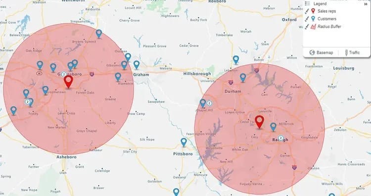
A radius map is a tool that shows how far you can reach from a specific point. Whether it’s a delivery hub, a storefront, or a warehouse, a radius map lets you draw a circle around that spot to see which areas fall within a certain distance or travel time.
But distance isn’t everything. That’s why modern tools like Smappen go a step further by offering isochrone maps—maps based on travel time, not just miles. These show how far you can get in 10, 20, or 30 minutes, taking into account real road networks and traffic patterns.
For businesses, that means you can plan routes, define delivery areas, or evaluate potential new store locations based on how easily you can actually serve customers—not just how close they are on paper.
Ways Businesses Use Radius Maps and Geo-Intelligence
Let’s take a closer look at the real benefits and practical uses of geo-intelligence:
- Smarter Site Selection
Choosing the right location for a new branch, office, or warehouse isn’t just about cheap rent or visibility. You need to consider who lives nearby, how easy it is to get supplies, whether there's enough foot traffic, and what the local demographics look like.
Geo-intelligence tools help you weigh these factors quickly and make decisions based on data, not instinct.
- Know Where Your Customers Are—and Where They Aren’t
Mapping your current customer base helps you see trends and patterns. You can identify areas that are performing well and spot underserved regions with potential. This information helps you target your marketing efforts and decide where to expand next.
- Optimize Deliveries with Travel-Time Mapping
If you rely on local delivery, time is money. Isochrone maps let you plan routes and define zones where deliveries can be made within a certain time frame. This helps reduce fuel costs, improve on-time performance, and increase customer satisfaction.
- Analyze the Competition Without Guessing
Understanding where your competitors operate helps you avoid oversaturated markets or target areas they’ve missed. While the goal isn’t always to go head-to-head, knowing the competitive landscape gives you an edge when planning your strategy.
What Data Should You Be Looking At?
Great geo-intelligence tools bring together multiple data points in one place. Here are the key ones to consider:
- Demographics: Age, income, household size, and lifestyle all influence buying behavior. This helps you target your offerings more precisely.
- Travel Times: Travel distance isn’t always helpful—how long it takes to get there is more important for logistics.
- Zoning and Infrastructure: Local regulations, traffic flow, and infrastructure (like public transit) can impact your ability to operate efficiently.
- Historical and Predictive Trends: Look at sales patterns, population shifts, or new construction to plan for future needs.
Platforms like Smappen allow you to overlay all these layers, helping you test scenarios and make decisions faster.
Best Practices for Smarter Mapping and Expansion
Want to get more from your maps? Follow these proven tips:
- Use Isochrone Maps Over Simple Radius Circles: Plan by travel time instead of just miles—it’s more accurate for real-world operations.
- Keep Your Data Updated: Customer behaviors and urban landscapes change. Refresh your data regularly to stay relevant.
- Segment by Customer Profiles: Use filters to look at age, income, or lifestyle groups—don’t treat all areas the same.
- Share Insights Across Teams: From marketing to operations, everyone benefits from geo-intelligence. Make it part of your cross-functional strategy.
Why Tools Like Smappen Are Game Changers
In the past, using geographic data meant hiring experts or learning complex GIS software. But tools like Smappen make it simple for anyone to start using location-based insights. The user-friendly interface lets business owners, marketers, and planners visualize data, build custom maps, and share findings quickly.
You don’t need to be a data scientist to make smarter decisions anymore.
Conclusion
Local delivery, site selection, and regional expansion are no longer based on gut feeling. With geo-intelligence and radius mapping, businesses of all sizes can act with confidence and speed.
Whether you’re running a delivery startup, expanding a retail chain, or managing logistics for a larger operation, using tools like Smappen helps you:
- Understand where to grow next
- Improve delivery times and reduce costs
- Make smarter, faster business decisions
In a competitive world where geography still matters, location data is your secret weapon. And with the right tools, it’s easier than ever to use.